Tuesday, 29 May 2018

Lyth Hill Countryside Site - Where to Go Near Shrewsbury in Shropshire.

A video about the glorious Lyth Hill Countryside Site, in our series on where to go near Shrewsbury in Shropshire, UK.


This site, on the outskirts of Shrewsbury, offers some of the best panoramic views of the Shropshire Hills.

Follow the paths through wide open grassy areas, and amongst oak woodland for relaxing walks.

This is the landscape that inspired the work of the famous Shropshire author Mary Webb, who used to live on the edge of Lyth Hill.

Image of Lyth Hill Countryside Site.
Lyth Hill - View toward The Wrekin

The views of the south Shropshire Hills, extend from The Wrekin in the east to Wenlock Edge in the southeast, and the Stiperstones in the southwest.
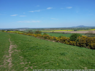
Image of Lyth Hill Countryside Site.
Lyth Hill grassland

The site with its areas of woodland, scrub, and open grassland provides a, wonderful wildlife refuge.

Historically, ropemaking was carried out on the site, with individual flax strands laid and twisted together on a rope-walk, similar to shown here, and located close to the track at the top of the lane.
and the author Mary Webb, author of 'Precious Bane', lived in Spring Cottage on the edge of Lyth Hill.
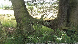
Image of Lyth Hill Countryside Site.
Lyth Hill - Oak Trees, joined together. Probably the result
of traditional hedge laying many years ago.

There is a good path network around the site, which is great for walks and jogging.

There are benches and picnic tables where visitors can sit and admire the view.

The Humphrey Kynaston Way long-distance bridleway passes through the site.

Next to the top car park, (accessed from the unclassified lane that leads through Lyth Bank), is a toposcope which describes the landscape and identifies the hills that can be seen.

WHEN will you visit it? Look up the route to Lyth Hill Rd, Bayston Hill, Shrewsbury SY3 0EW, UK

Please comment below!

We make videos, and we'll make you one as well! Just send us your text content! www.ippts.info

Sunday, 29 April 2018

Burrs Field Kingsland Shrewsbury - A Story of Lead Manufacture During the Industrial Revolution

Burrs Field Kingsland - The Story of Lead Manufacture in Shrewsbury.

This is the Story of Burr's Field Between Kingsland Bridge and Longden Coleham.

Shrewsbury was once an important lead manufacturing town.

Watch the story by viewing our video below, please do give us your comments and perspective upon the Burr's Field Lead Works.


The lead works were owned by the Burr family and were situated near the river Severn in Kingsland, to the left of the Kingsland Bridge.

Once a dirty fuming and noisy scene of industry it is now pleasant public parkland.


Image shows Burrs Field Kingsland, Shrewsbury
Location of Burr's Field - Copyright Google Maps


The story is that: The Burrs were a London-based family of plumbers.

Thomas Burr, moved to Shrewsbury in 1813, and started 80 years of lead manufacturing in Shrewsbury.

His family had patented an invention known as the ‘Burr’s Lead Squirting Press’.

Using this he was able to make lead pipes more cheaply than his competitors and his business prospered.

In 1829 he moved his business from within town, and notably built a shot tower, allowing him to add lead-shot for gun cartridges, to his products which included paint and cosmetics.

The shot-tower was 150ft high, 30ft in diameter at its base and 12ft in diameter at the top.

In the shot tower molten lead was passed through a copper sieve at the top of the tower, and the falling lead landed as lead-shot balls, in a water bath at the bottom.

Burr’s lead works were heavily criticised on account of the bad smelling smoke, soil, and water pollution they caused.

In modern times chemical analysis of the ground near the factory showed 780 grams of red lead per square foot.

The modern maximum for a safe blood lead level is far lower and less than one 10 millionth of a gram.

No wonder that the workers suffered from lead poisoning, and early deaths.

Even now, the factory site is too contaminated to be used for agriculture or housing.

Text: Based upon Dr Andrew Pattison's article at his excellent website shrewsburylocalhistory.org.uk

Note: All images are illustrative only for your entertainment, and do not necessarily represent the long demolished buildings in Burrs Field etc..

Saturday, 28 April 2018

Shrewsbury Places - The Mount - Charles Darwin and Tourism Opportunity

Information about another historic part of Shrewsbury town with associations with Charles Darwin.

So many people liked the last video about Frankwell, that I thought I would stay in the same part of town with this video.

The Mount is the site in Shrewsbury on which stands the Georgian house, officially known as Mount House, but often itself described simply as The Mount, which was the birthplace of Charles Darwin.


The Georgian house was built in 1800 by Charles Darwin's father, the local very successful doctor Robert Darwin.

His son Charles was born there on 12 February 1809.

Robert Darwin died in the house on 13 November 1848, followed by his unmarried daughters Catherine and Susan.

Since there were no surviving members of the Darwin family in residence, the house was then put up for auction.

Since 2004, the house is occupied by the District Valuer and Valuation Office of Shrewsbury.
according to Wikipedia, visits may be made by appointment during office hours.

The lease on the current use of The Mount, expires in 2021.

The building is grade II listed, but the site is not recognized as a museum.

Down House, in South London, where Darwin spent most of his adult life, is the museum dedicated to his life.

In February of this year it was suggested that Charles Darwin’s Shrewsbury home could become a popular tourist attraction.

A Shropshire Star article said that a working party will be set up to look at buying Charles Darwin's Shrewsbury birthplace and turning it into a tourist attraction.

It is clear, however, that Council funding for such a venture would be unlikely to be available.

With the global importance of Darwin's work surely there would be enormous potential for another Darwin Museum?

Read more at the Shropshire Star website

Saturday, 21 April 2018

Frankwell Shrewsbury - Medieval river port, bridges and buildings

The Story of Shrewsbury: Frankwell District of Shrewsbury is a story of a medieval river port, old and new bridges and wonderful old buildings from half-timbered wood framed houses to Edwardian style professional and wool merchant residences.

This district is a joy to walk around in and enjoy the variety of streets and architectural styles, from medieval to modern.

The Shrewsbury Council Guildhall, and the Theatre Severn are the newest additions to the area. Not in themselves noteworthy architecture, of course, but no less important to the community benefits of the area.

Now watch our video (below) about Frankwell. Afterwards don't forget to scroll on down below this video for more info about Frankwell, Shrewsbury.

Anchor Inn, Shrewsbury

The Anchor was in danger of going out of business at the turn of the century following repeated flooding of the nearby River Severn. However, the erection of flood barriers in 2003 has alleviated the situation, and trade would have gained a boost thanks to the Theatre, which opened in 2009. via AnchorInnShrewsbury

Frankwell Quay History

Back in the day, Shrewsbury had a lot of river trade. Walk down the water lane behind St Mary's, and you'll see the archways of former shopfronts for the people arriving by boat, and by the river itself is still the area where boats would have been tethered up, complete with stone steps up from the water to the walkway. The walkway itself originally was built for horses toeing barges, but now it provides the means of a lovely stroll. Well, maybe not right this second. Currently it's overflowing due to recent rainfall. But beneath an inch or so of water, that walkway is totally there!

Illustration for the story of Frankwell, Shrewsbury
However, Shrewsbury actually retains very little of its river trading past, and what little it does have, a lot of people know absolutely nothing about.

For those of you who don't know, the river severn loops around Shrewsbury, almost making it into an island.

This island contains the castle, and it was all wrapped up neatly by the town walls.

So hundreds of years ago, any settlement on the other side of the river, outside the walled borough of Shrewsbury, existed independently of the towns jurisdiction.

The people of Shrewsbury referred to the nearest of these settlements as Little Borough. But the residents took to calling it Frankville, which meant "Town of free trade." It boasted its own mayor and its own festivals, and despite its small size, the census in 1881 reveals that there were fifteen pubs in the little borough at that point in time.

Today, it is just part of Shrewsbury, known as Frankwell. Through the Victorian era, Frankwells history became colourful with prostitution and this persisted into the 20th and 21st Century, and in 2006 it made headlines when two prostitutes were bludgeoned to death with a hammer in a brothel. But that aside, Frankwells history is primarily to do with the river trade.

Some of the old buildings in Frankwell are remarkably old, dating back to the early 15th Century. But Frankwell Quay, with the exception of two old, unused buildings, has been modernized quite a bit, housing the council offices, the theatre, and a car park. The two unused buildings seemed to have survived amongst the modernization, but for how much longer is currently a topic of discussion.

While these buildings were constructed in the 1700s, records of Frankwell Quay date back to 1405, when James Callerode described "the stew" as a land, a croft and dovecote just upstream from St Georges bridge.

St Georges bridge stood just upstream from where the old welsh bridge stands today. In fact the Welsh Bridge was built to replace it.

The name "The Stew," while being an overall name for the land back in the 1400s, is retained by one of the buildings here today. via Shrewsbury from where you are not: Frankwell Quay

Frankwell in the Early Modern Period

Frankwell was highly prosperous in the sixteenth to eighteenth centuries. 4-7 Frankwell is an imposing building with ground-floor shops and first- and second- floor workshops above, built in about 1590. 113-14 Frankwell, built around 1620, remains a splendid and imposing half-timbered building. Late seventeenth and early eighteenth century buildings, including the 'Anchor' public house, line the corner to the approach to the old Welsh Bridge.

The old Welsh Bridge (St George's Bridge) was replaced by the present day Welsh Bridge in the 1790s. The new Welsh Bridge is located some 70m (80 yards) further downstream from the old bridge.  via Frankwell : Wikis (The Full Wiki)

Wheatsheaf Pub, Frankwell Shrewsbury

This black and white former coaching inn features an inglenook fireplace, beamed ceiling and bay windows in the bar. This is a comfortable room which was refurbished in 2014. There's another small room to the rear of the pub, that is used as a games room. The serving area is triangular-shaped which is fairly unusual. Three handpulls dispense beers from local and regional micro breweries, usually with a real cider as well.


There is keen emphasis on music, particularly at weekends when live bands are often in evidence, though the jukebox is usually active the rest of the time, Barbecues are often held on the large beer garden decking in the summer. In its time it has been owned, not only by the Wrekin Brewery of Wellington, but also was part of the large local estate of the Shrewsbury & Wem Brewery.
Historic Interest

The black & white building with the triangular frontage opposite used to be a pub called the Old Bell up until 1910. This used to be the home of the Frankwell Brewery, which was producing up to 200 barrels of beer a week in the 1880s. via Wheatsheaf, Shrewsbury • whatpub.com

Flood alleviation scheme: Frankwell, Shrewsbury

Shrewsbury is the county town of Shropshire with a population of approximately 100,000 people. It has a rich architectural and historical heritage and is one of the best preserved medieval towns remaining in England. The town centre stands on a hill in the middle of a narrow necked horseshoe loop of the River Severn with the river surrounding most of the town’s historical centre.

The Frankwell scheme Feasibility studies identified the Frankwell area of the town as the area most likely to be eligible for a flood defence scheme. Frankwell is the first area in Shrewsbury where a substantial number of properties are affected by flooding. In addition, much information on this area was already available from earlier investigations, allowing an accelerated programme to progress. Prior to the scheme, there were no flood defences in Frankwell. The heights of the existing riverbanks and riverside buildings varied. It was estimated that many properties in Frankwell had no more than a 1 in 3 year standard of protection.

The Agency adopted a creative and innovative approach because heritage and aesthetic considerations were paramount. The resulting scheme combined traditional stone clad floodwalls and embankments with new demountable defences. These are only erected in the event of a flood. For the majority of the year, when the river is not a threat, they will simply not be there.

The Agency is responsible for the storage and erection of the demountable defences and when not in use, the barriers are stored locally. The flood defences principally consist of steel sheet pile underground walls up to 16 metres deep, which limit the flow of groundwater under the defences.

They also act as a foundation for reinforced concrete walls up to 3 metres high and demountable aluminium barriers. The demountable defences have been designed so that they can be erected progressively.

This means that when a flood warning is issued the defences are erected in a particular sequence thereby increasing efficiency and providing a longer time to erect the barriers in advance of a flood. If flooding is imminent, only the demountable barriers necessary to stop flooding will be erected. Shrewsbury is fortunate in that the Agency is usually able to provide at least 6 – 12 hours warning time.

The longest single section of demountable defences is along the ‘promenade’ at Frankwell Quay, an area that has been significantly enhanced as a result of the scheme.

The works have also included major improvements to the drainage system, including the construction of two new large pumping stations by Severn Trent Water Ltd.

These will reduce the risk of flooding due to backing up of the drains. Under normal circumstances, the pumping stations will operate automatically. However, they are monitored remotely from the Severn Trent Water control room and can be operated manually if required. Flood risk can never be completely removed. The Frankwell scheme has been designed to provide a 100 year frquency protection level. via Flood alleviation scheme: Frankwell, Shrewsbury - GOV.UK

Saturday, 24 March 2018

Meole Brace - Shrewsbury - History and Facts

Read this and watch the video we made below, about Meole Brace, Shrewsbury. 

We explain the fascinating history and facts about the village of Meole Brace, which is situated on the Rea Brook, near Shrewsbury, Shropshire, UK. And, we do it in less than 2 minutes!


Meole Brace is a south-western suburb of Shrewsbury, Shropshire, England.

The Rea Brook, a tributary of the River Severn, flows through the area.

Locally the brook was, in the past, known as the "Meole Brook".

The name Meole Brace comes from an old Saxon manor house, which no longer stands, owned by the Brace family (perhaps originally 'de Bracey': Norman barons).

It has been known as Meole, or Mole, or Mill for almost 1,000 years; or possibly from the Welsh 'moel' meaning "bare", or by extension "bare hill" - or from Old English mele, "meal" as in "oatmeal", or possibly from the Welsh 'moel' meaning "bare", or by extension "bare hill" - or from Old English mele, "meal" as in "oatmeal", referring to the sediment in the brook giving a "mealy" appearance.

The A5112 (Hereford Road), formerly the A49, runs north-south past Meole.

The old part of Meole Village, lies on the route of a Roman road and could be even older than the town of Shrewsbury.

The village has a church, Holy Trinity Meole Brace.

Built at a cost of £7,500, it was consecrated in 1869 and is a Grade II listed building.

The  ground, home of Shrewsbury Town F.C., is nearby.


Sunday, 25 February 2018

Old St. Chad's Church - The Story of a Sudden Building Collapse in Shrewsbury 1780s

Old St Chad's Church, Shrewwsbury
Old St. Chad's Church Clock Chimes Struck at 4 am - WHAT HAPPENED THEN?

This is one of a series of videos about Shrewsbury Local History Events, and it took place in the 1780s.

Watch our video below for the answer, but don't forget to return afterwards to SCROLL DOWN this page for the full article.


A local stonemason was employed by the churchwardens of the Old Saint Chad's Church to mend some alarmingly large cracks that had appeared in the church.

As it was nearly midsummer he started work at 4am, and went to the sexton’s house nearby to collect the key.

While he did so the church clock struck 4:00.

The heavy movement, caused a vibration which was the final straw for the tottering structure, and, he, and two chimney sweeps working nearby noticed that the tower "suddenly opened".

It stood for a moment, as it were, suspended on the balance, and FELL; as it sunk, a cloud of dust rose so high, that for a while it concealed every surrounding object.

When the dust fell-away the whole area was spread with masses of stone, lead and timber, they lay in confused heaps, mingled with the shattered remains of pews, monuments, bells, and fragments of the gilded pipes and the framework of the noble organ.

The north side of the church had gone, while the whole of the south side of the tower hung in the air, with portions of its beams threatening destruction to any who would dare approach them,’ a contemporary wrote.

Furthermore, this need not have happened if the church authorities had listened to the advice, which was given previously by the young Thomas Telford, to start his recommended repairs, urgently.

In this capacity as County Surveyor he had previously been asked by the churchwardens of St Chad’s Church to report on some rather alarming cracks that had appeared in the building.

Telford had presented his report, ending with the words, “I think, Gentlemen, that if you have any other business to discuss, you would be wise to continue your meeting elsewhere, since this church may fall down on our heads at any moment.”

However the churchwardens chose to ignore the advice of the young Scotsman, and had employed that local stonemason alone to remedy the defects.

After much debate, the new St Chad’s Church was built near the Quarry, which stands to this day, but contrary to what you would expect Telford was not asked for advice on that.

Not that it mattered to him, because the fear of other medieval churches collapsing into oblivion, gave Telford lots of work, and he designed and oversaw the building of several new churches, in Shropshire at that time.

Attribution: Image of Old St. Chad's Church is by Richard Symonds (Own work) [CC BY-SA 3.0 (https://creativecommons.org/licenses/by-sa/3.0)], via Wikimedia Commons

Tuesday, 13 February 2018

English Civil War and the Dramatic Seizure of Shrewsbury - Part 18

English Civil War -  Dramatic Seizure of Shrewsbury - Part 18 of the Story of Shropshire - The English Civil War 1642 to 1645

See Note 1 for attribution
The year of 1642 brought the horrors of the English Civil Wars, in which the Parliamentarians (led by men like Essex, Fairfax, and Cromwell) rebelled against King Charles I, whose government they considered to be arbitrary and oppressive.

Shrewsbury, like most of Shropshire apart from Wem, was strongly Royalist.

Watch our video below, but don't forget to come back here, after watching the video SCROLL ON DOWN THIS PAGE and tell us what you think, by commenting!


King Charles I visited the town in 1642, and Prince Rupert arrived and stayed for a few weeks in 1644. while Charles was there he recruited men for the disastrous campaign which later led to a Royalist defeat, in the famous battle of Marston Moor.

To prepare for any Parliamentary attack, the townspeople built additional fortifications which ran across the northern end of the town. Unfortunately, there does not seem to be any evidence of those walls still existing today.

These included a fortified wall, and a ditch which reached from the Castle all the way to the western loop of the River Severn, and another wall and ditch which should have reached all the way to the eastern loop.

Unfortunately, it didn't - and the gap was filled by nothing stronger than a few feet of wooden palisade.

Learning of this weakness from their spies early in 1645, the Parliamentarians at Wem entrusted Lieutenant-Colonel William Reinking with a force of twelve hundred men and instructed him to seize Shrewsbury.

Setting out from Wem by the light of the moon, on the evening of Tuesday 21 February, Reinking and his followers are said to have reached Shrewsbury at about 4 O'clock on Wednesday morning.


The main body of some eight hundred horsemen halted to the north of Castle Foregate, while the other four hundred dismounted, and made their way across the fields towards the wooden palisade by the river.

Reinking had brought carpenters with saws and axes to cut down the palisade, but when they arrived he was afraid that the noise of breaking down these fences would wake them, and alert the garrison to their presence.

So he launched a small boat on the River Severn, loaded it up with men, and told them to row it up-river and land inside the defences. However, the current in the river that day, was apparently too strong for them.

Twice they tried and failed to by-pass the defences in this manner; and then they were seen by a royalist sentry, who gave the alarm. They realised that, at that point, it was too late to worry about making a noise. So, Reinking and five of his men rushed immediately to the palisade, and broke it down.


That allowed the infantry to rush through the gap.

One group of fifty are said to have used ladders which they had brought with them to scale over the town wall where it ran along the riverside. Once through they dashed across the town to open the northern gateway.


But, Sir Michael Earnley led a small sortie from the Castle, in an attempt to prevent them from reaching the gateway. In the melee that took place his men were swept aside, and he himself was seriously wounded.

So it was, a few minutes later, the gateway had been captured. The drawbridge was let down, and eight hundred Parliamentarian cavalry were rode into the town virtually unopposed.


Meanwhile Reinking, at the head of the other three hundred and fifty men, who had streamed through the gap in the palisade, went forward to St. Mary's Watergate. In those days a tower and sentry point was attached to the Gate.

However, the guards, both at that location, and at another fort higher up the lane (where it was crossed by the town walls), were traitors.

A pre-agreed password was given by the invaders, and the guards immediately opened the gates. This allowed the Parliamentarian infantry to stream into the town.

They reached the street between the castle and the town, just as the cavalry came up.

Reinking was given a horse once again, and led an attack upon the 'Court of the Main Guard', which stood on the site of the present market square.

This was overcome after a short struggle in which it is said that Reinking had his horse killed under him.

Most of the royalist officers were taken in their beds.

That ends the story for us here.

Miraculously, the total loss on both sides was only seven men and one captain, and the Roundheads had gained the town.

Text based upon The Story of Shrewsbury, by Richard Graves, Hardwick House, Ellesmere 1993.

Charles I image: By Sir Anthony Van Dyck (1641 - 1641) Details of artist on Google Art Project - BQHR9te2WWtyOA at Google Cultural Institute , Public Domain, Link